
PTC8 Post-Storm Reflections, Resources & Information
Reflections on this Week’s Storm
The people of Brunswick County have had a difficult week. What was forecast to be a weak potential tropical system with three to six inches of rain turned into a historic storm that dumped 18 inches of rain on some portions of our county in less than 12 hours. Candidly, the amount of rainfall and its effects caught us off guard. My heart goes out to those whose homes, vehicles, and other property were flooded, and I share the frustration of those who are unable to travel where they need to travel due to road closures. I can only imagine how frustrating it was to be trapped in your vehicle all day — or even overnight.
Post-Storm Resources & Information
Below are links to several resources that may be helpful to those of you who were affected by the storm:
- Post-storm updates from Brunswick County government
- Road closure information from Brunswick County government
- Road closure information from NCDOT
- Volunteer
- Contact me if you have a request or need information not listed above
More Reflections on this Week’s Storm
I’m extremely grateful for the sacrifices of our first responders who braved this storm to protect the rest of us. Many of our county staff spent the night at the county government center.
I’ve also read and heard the frustrations expressed by many of you in the aftermath of this storm. I share many of them. While the intensity of the storm was far greater than predicted, we must learn from it and be better prepared next time. I am taking notes on specific things we need to improve in terms of our preparation and response, and I believe the other commissioners are doing the same. If you have any specific observations we should consider, please click here to send them to me. We will address those once immediate response portion of this event has passed.
Now, let’s talk about what a unique and, in my mind, strange storm this turned out to be.
What Was Predicted
After the storm passed, I went back and re-read the National Weather Service briefings from the night before and morning of the storm:
Sunday, September 15, 2024 – 5:30 pm briefing
– Rainfall amounts of 3 to 6 inches (+isolated higher amounts)
– Moderate impact from rain & flooding
Monday, September 16, 2024 – 7:40 a.m. briefing
– Additional rainfall of 2 to 5 inches (+isolated higher amounts)
– Moderate impact from rain & flooding
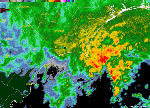
Actual Rain Totals
Obviously, we received much more than what was predicted, and it fell in a short amount of time. Below are gauge-measured totals across southeastern North Carolina and northeastern South Carolina. These originate from a variety of networks including NWS ASOS, FAA AWOS, CoCoRaHS, NWS cooperative observers, CWOP, and Weather Underground.


From the National Weather Service:
“Historic rainfall occurred across the Cape Fear Region of southeastern North Carolina on September 16, 2024. Gauges and automated radar estimates showed that 12 to 20 inches of rain fell in only two days, creating severe flash flooding affecting Carolina Beach, Southport, Bolivia, and Boiling Spring Lakes. Although this system never became a named tropical system, observed weather impacts including strong winds, heavy rain, and flash flooding were similar to tropical storms and hurricanes of the past.
“Extreme flooding developed across portions of Brunswick County and lasted for days. A river gauge installed at the Lockwood Folly River at NC Highway 211 recorded its second highest stage on record, 19.06 feet, only 1.7 feet below the record set back in 2018 during Hurricane Florence.”

Also from the National Weather Service:
Winds
“Even though this system never became a full-fledged tropical cyclone, wind gusts over 50 mph were recorded in a number of locations. While most of these higher winds occurred near the Cape Fear coastline in association with the heavy rain squalls racing onshore, a second area of strong northerly winds gusting to 45-55 mph developed during the afternoon well inland from Lumberton to Dillon to Florence. This appears to be as cool, dry air was pulled into the western periphery of the storm’s circulation, promoting mixing of stronger winds down from aloft.”

To wrap it up, Potential Tropical Cyclone #8 was far stronger than advertised, and the storm exposed some thing we need to work on. As I said earlier, I will be making recommendations on ways to improve our response, particularly in terms of communication with the public. If you have any specific observations we should consider, please click here to send them to me.